Monday 30 May 2016

Pushing over the Bridge

[Any of the images can be clicked to enlarge.]


Background

The Infirmary Bridge in Inverness crosses the River Ness upstream of the city centre.
It takes its name from the nearby Royal Northern Infirmary (RNI) which now houses the Executive Office of UHI (University of the Highlands and Islands).
On the far side is Cavell Gardens, named in memory of Edith Cavell. (In spite of pronunciation by many locals, the correct stress is as in 'travel' rather than 'Ravel'.)

This suspension bridge, built in 1881, is 90 m long with only 1.7 m available width, nearly level, and connects two relatively quiet roads along the riverside.
These three photos were taken earlier this year and show the bridge as it was until a few weeks ago.
There were a couple of 'No Cycling' signs one of which had its red circle partly obscured with 10 plain address labels (plus an NHYES sticker from the time of the Scottish Referendum).


Traffic Regulation Order

A major project is under way in the Highlands to repaint 94 miles of lines on the road surface and replace 1,600 road signs.

As part of this, messages were painted at the entrance to both ends of the bridge augmented by two extra 'No Cycling' signs.
Approaching the bridge the message says 'Cyclists Dismount' in 18" (45 cm) high letters.
Leaving the bridge the message was 'Beware' but strangely this was burned off a few days later.


Typical Peak Weekday Traffic

Data was gathered between 8 am and 9 am for 96 pedestrians and 38 cyclists.
Percentages Pedestrians Cyclists Both Modes
Cavell -> UHI 50 19 69
UHI -> Cavell 22 9 31
Both Directions 72 28 100


The different counts in each direction is mostly explained by where the people work.
The opposite would be expected at the end of the day.
There were a few joggers and walkers with buggies and dogs among the pedestrian numbers.
I initial attempted to do a separate count of cyclists cycling and walking but I abandoned this because quite a few changed mode (sometimes more than once) as they crossed.


Observations

Pedestrians crossed singly or in groups of up to four taking about a minute.
Some trailed wheeled luggage, pushed buggies or were accompanied by dogs.
Some stopped to take photos or look at the view. Some were jogging.

Cyclists usually travelled alone and could cycle across in about 20 seconds.
Some cyclists walked the full length while others cycled for all or part of the crossing.


There is only 1.7 m of available width. Walking two abreast is comfortable but cycling two abreast is not really an option. This naturally means that cyclists have to take care when passing other users of the bridge and will usually only overtake a pedestrian with consent.


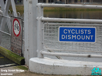
Signs on Metal Plates

The Greig Street Bridge, near the city centre, is of similar construction but slightly wider at 2.3 m. It also has a more obvious rise in the middle. It has rectangular blue 'Cyclists Dismount' signs at each end. Being advisory, they can be ignored (and often are) provided the cyclist takes account of other bridge users. It also has two red circle 'No Cycling' signs at each end. Their lettering is badly weathered  and their position on the side barrier of the bridge makes them easy to overlook.


The Infirmary Bridge has two new red circle 'No Cycling' signs at each end. This is an order and failure to comply is potentially an offence carrying a fine.


Other Locations

There is no prohibition on the paths or bridges further upstream in the Ness Islands. Indeed there is an official cycle route (The Great Glen Way) through the Ness Islands.

Core Paths

It is worth noting that both of these suspension bridges are Core Paths.
This is a legal term that grants a legal right to walk or cycle that route.

Map_9___Inverness_West.pdf
IN19.06 - Greig Street Bridge
IN19.07 – Infirmary Bridge

It would appear that the 'No Cycling' signs contradicts this basic right.
Invalid prohibition signs that are likely to be ignored put the law into disrepute.

Conclusion

Cyclists walking or cycling across these suspension bridges already appear to show consideration for others on the bridge.

The narrowness of the Infirmary Bridge naturally encourages cyclists to stop and give way to pedestrians or cyclists passing in the opposite direction. The main justification for overtaking is when pedestrians stop to take photos. This is typically done politely with appropriate care.

The Greig Street Bridge is 0.6 m (2 feet) wider and provides greater width and better sight-line than some local shared-use pavements (cycle tracks). Cycling across the bridge is quite common and is typically done with consideration. Cyclists will usually walk their bike if the bridge is busy. Each end is constricted by a pair of right-angled corners. BMX riders often leave the bridge by jumping the steps. (Some even jump up the steps.)

'No Cycling' signs contradict the reasonable access right of a Core Path.
'Cyclists Dismount' signs are often an indication of poor design. Here they are simply not appropriate.
The painted messages on the surface are unsightly.
All of these signs only serve to disrespect cyclists and encourage others to quote the law: - “Can't you read the sign?” - no matter how much care the cyclists show.

I have asked the Highland Council to remove these new messages and signs.


They could more suitably be replaced with a round, blue shared-use sign.

If it is really thought necessary, they could be supplemented with a blue rectangular sign with the text such as 'Pedestrian Priority'.

Your comments are welcome.


Monday 9 May 2016

Antisocial Parking on Huntly Street


[Any of the images can be clicked to enlarge.]


Background

Huntly Street, Inverness is a restricted zone. The road is single lane one-way with a shared-use pavement on the river side and a pedestrian pavement on the other. Contra-flow cycling on the road is legal. Being a restricted zone, there are no yellow lines on the road but there are signs on lampposts at entry points and along the length of the road.
The shared-use pavement has a kerb flush with the road to give a pedestrianised feel but this unfortunately makes it too easy and inviting for drivers to drive onto and park their vehicles.


Enforcement

The Highland Council are preparing to take over parking enforcement (expected in November). Currently it remains the responsibility of Police Scotland. This usually means Traffic Wardens of which there used to be two for the whole of the Highland area (11,838 sq miles or 30,659 km2) but I believe there is now only one.


Law

I'm no legal expert but here are several key facts.
A pavement along the side of a road is legally referred to as a footway.
In Scotland, it is an offence (with certain exceptions) to drive on a footway but parking is not so clear.
Sandra White MSP (Glasgow Kelvin) has proposed legislation, The Footway Parking and Double Parking (Scotland) Bill, which has been agreed in principle by the Scottish Parliament.
However, a shared-use pavement (walking and cycling) is legally a cycle track.
Parking a motor vehicle on a cycle track is a definite offence under the Scotland (Roads) Act 1984
http://www.legislation.gov.uk/ukpga/1984/54/pdfs/ukpga_19840054_en.pdf
Part XI Offences 129 (6) - [Page 85]
"A person who parks a motor vehicle (...) wholly or partly on a cycle track commits an offence."


Parking Space

There is ongoing discussion about whether or not Inverness has adequate parking space provision. This will not be discussed here. This blog accepts the signage and law as it presently exists.
Focus here is on the section of Huntly Street shared-use pavement between Greig Street Bridge and the main Ness Bridge which includes a Loading Bay (which is a Parking Bay on Sunday) and a Disabled Bay.
As well as the motor traffic, Huntly Street is popular with people of all ages and (dis)abilities, with buggies, bikes and mobility scooters. It should provide an enjoyable walk/ride along the riverside.
Since the completion of the new flood wall [Huntly Street Uncovered] almost a year ago, the shared-use pavement has been frequently occupied with parked motor vehicles.


Experiment

On Sunday morning 08 May 2016 between 10am and 11am I approached drivers who had newly parked their car and asked them if they knew that that they had parked on a pavement or in a disabled bay (as appropriate).
Based on previous observation, I'd expected more vehicles to be parking but was pleasantly surprised to find there weren't too many so I was able to approach almost all the drivers directly and speak with them.


Results

Many drivers seemed genuinely surprised that parking on the shared-use pavement (cycle track) is an offence. Common responses were:
- It's OK on a Sunday.
- The Police have given us permission.
- Everyone else is doing it.
- I've parked here before.
- Where does it say that?

The attitude to parking in a Disabled Bay without displaying a Badge was similarly casual (although the responses were more apologetic and cooperative):
- I didn't see the sign.
Out of 6 cars, 1 displayed a badge, 4 moved on when informed, and 1 was briefly dropping off a passenger. Another 2 stayed on the road to drop passengers off.

Activity on the pavement near the Premier Inn seemed to be visitors leaving who had either parked on the pavement overnight or were being picked up by a taxi. There is a lot of pavement parking there at other times and may be the subject of a future study.

Activity nearer Greig Street was obviously related to church attendance, particularly at St Mary's.

Out of 8 drivers who parked on the pavement near the Greig Street Bridge, 1 already there moved away, 3 moved away after being informed, 1 walked over the bridge, 3 listened/discussed but stayed parked.

These latter four cars can be seen in the photo. Also in the picture is the 'Shared-Use' sign and a 'No Waiting At Any Time' sign. I purposely avoided photographing people but there were a lot around. To pass the parked cars, pedestrians would have to squeeze through the gap beside the wall or transfer onto the roadway.


Conclusion

These few inconsiderate parkers believe themselves to be more entitled than genuine pavement users. Even worse, they also act as a bad example and attract other less self-assured motorists to copy them.

Your comments are welcome.

Monday 8 February 2016

Shared Space Storm


[Any of the images can be clicked to enlarge.]

Last week, while Storm Henry was howling through the north of Scotland, I went to Edinburgh for the day to meet up with colleagues planning the Walk Cycle Vote campaign.

Travelling by bus from Inverness, gave me almost 4 hours each way to read the online documents relating to the bill that Alexander Taylor's recently lodged with the Scottish Parliament.

This bill “urges the Scottish Government to place a moratorium on all shared space schemes until safety and equality concerns have been addressed.”
It comes with 53 supporting documents of written evidence.

In truth, you don't need to read much of this evidence to realise that shared space, as it's being implemented in the UK, is a disaster for disabled people, particularly those with sight loss.

If this issue is new to you, a good place to start is with the “Sea of Change” video that was premiered in the House of Lords at the end of 2013 and is now available online.

Lord Holmes of Richmond MBE (Chris Holmes), being blind himself, is a strong campaigner.
This page on his website has many excellent links.

He published a very readable report in July 2015
Accidents by Design: The Holmes Report on “shared space” in the United Kingdom

Lord Holmes secured a debate on this subject in the House of Lords 15 Oct 2015.

More recently, Alexander (Sandy) Taylor and Margaret Hutchison gave evidence to the Public Petitions Committee at the Scottish Parliament on 26 Jan 2016. (The first 39 mins of this video.)

Something like shared space had been attempted before in other places but the term 'shared space' originated with the Dutch traffic engineer, Johannes (Hans) Mondermann (1945-2008).

He was born in Leeuwarden (Friesland) and, as a traffic engineer, created shared spaces in that area as well as Groningen and Drenthe – the three Provinces in the north of the Netherlands.

His key philosophy was that road users (pedestrians, drivers, cyclists) must negotiate their way by interacting with each other. To bring about this change in behaviour, all traffic controls such as traffic lights, lane markings and kerbs are removed.

The idea is attractive and has much to commend it but two serious problems need to be resolved:

1 – Greatly reduced motor traffic is a prerequisite for shared space to work. Creating shared space should not be used in an attempt to reduce motor traffic.

2 – Because negotiation is expected to be mediated by eye-contact, navigating shared space is impossible or very difficult for sight impaired people and many other disabled people. These people have a continuing need for controlled crossings and clear, uncluttered routes.

I'll end with some tenuously related thoughts.

The rabbit and duck illusion (Kaninchen unde Ente) has been known for over 200 years old.

The same image can be perceived in two distinct ways by the same observer at different times.


Two groups can each hold to one of these views with possible conflict.

The lack of clear priority can result in shared space being viewed as either a pavement (by pedestrians) or a roadway (by drivers) and consequent conflict between the two groups.

Cyclists can end up somewhere in between and disliked by both the others.


Like Mondermann, the Dutch graphic artist, M. C. Escher, was also born in Leeuwarden.

At first glance his print, Waterfall (1961), appears simply to show water falling down two levels and over a waterwheel.

The water then flows away down a zigzag channel but this mysteriously returns the water to the top of the waterfall.

Focusing our attention locally, there appears to be no problem with any individual component. And, indeed, the individual components can all be built.

But, taken as a whole, we know it can't be right as it contradicts the laws of science. And if we had built the individual components, we'd find we couldn't join them together.

This illustrates a potential flaw in taking a tick-box approach to design.

The typical goals of shared space are to have smooth traffic flow while simultaneously allowing people to walk in and about the space. Without reducing traffic flow, these are incompatible goals.


People are more likely to have heard about Mondrian than the similar sounding Monderman.
Piet Mondrian (1872-1944) was a Dutch artist who was born near Utrecht. During his life he spent time in Amsterdam, Paris, London and finally New York.

A gallery of all his work sorted by year:

His early paintings are similar to the like of Van Gogh.
He then moves onto more abstract representations of subjects like trees.
From 1918 onward he produces the rectangular grids for which he's best known.


Many, such as (the catchily titled) Composition II in Red, Blue, and Yellow, are characterised by grids of strong, black outlines around a few coloured rectangles on a white background.


His Broadway Boogie Woogie (1942/43) eliminates the black outlines to successfully capture the shimmering lights of Broadway.


Reducing the visibility of kerbs by making level surfaces and using variously coloured pavings and setts may create a sense of place but it also creates a space that is impossible for sight impaired people and their guide dogs.

I feel another storm is coming.

Your comments are welcome.